

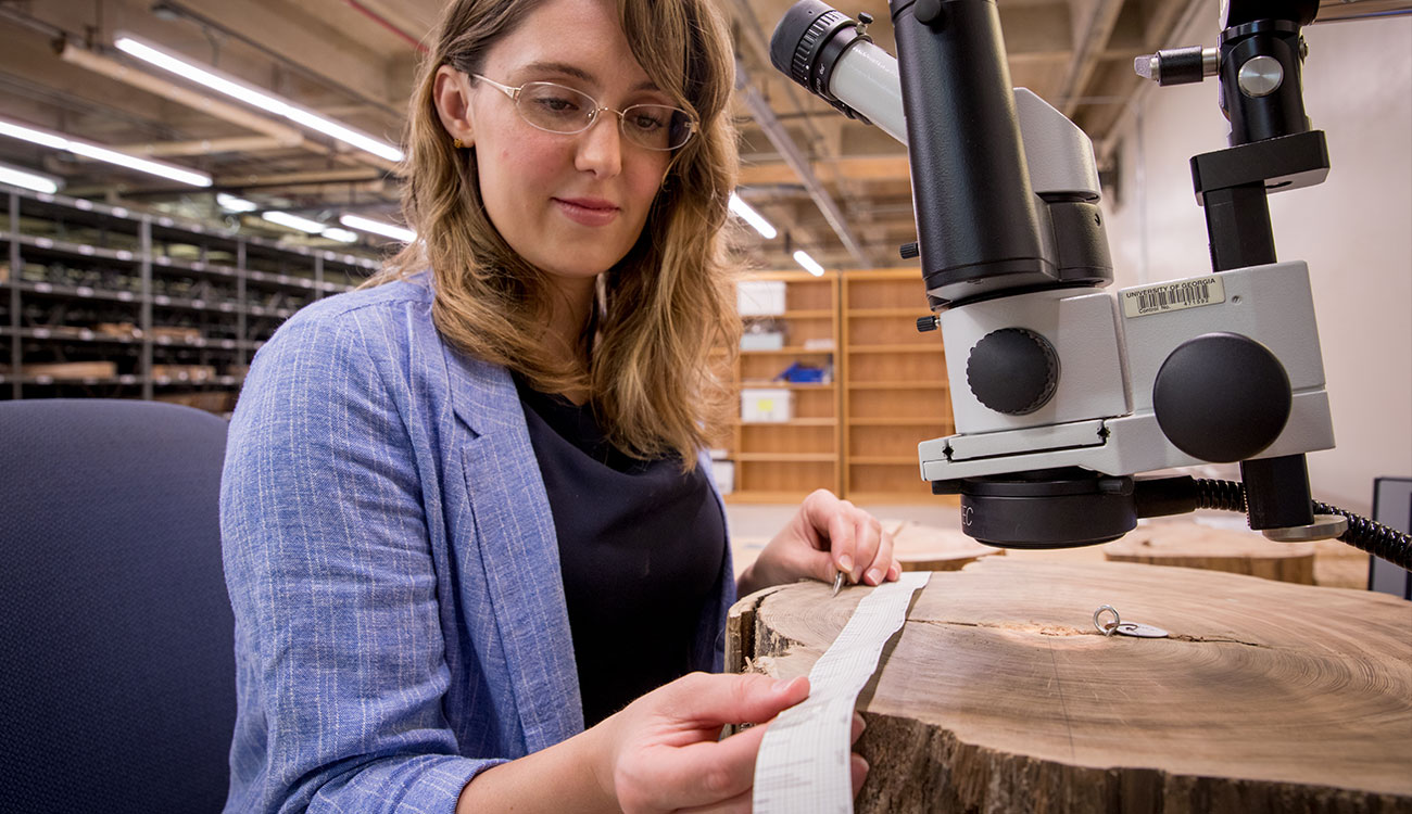
Trees in temperate environments grow one ring every year, and trees growing in the same area develop the same annual pattern of thick and thin rings, based primarily on rainfall. To create her chronology, Napora measured each sample’s rings and then matched the ring-width patterns among the samples. (Photo by Nancy Evelyn)
Cookies and crowbars
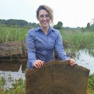
Napora’s oldest cypress sample is a 7,000-year-old knee found on Champney Island. A cypress knee is a knob that sticks up from the root, possibly to get oxygen, since cypress can grow in flooded environments.
The knee and her other samples are stored on metal shelves in a warehouse on South Campus. The majority are slices of trees—called cookies—that smell faintly of resin even though they’ve been buried at the mouth of the Altamaha River for hundreds and even thousands of years. Most came from Butler Island, north of Champney Island, and each of the 123 cookies has a small round tag with a number on it.
“Here’s some bark on this one,” Napora said during a pre-pandemic tour of the facility, “and this one died around three-and-a-half thousand years ago.”
Some of these trees were living in January 1846, when Charles Lyell, one of the founders of modern geology, travelled up the Altamaha River during a trip that was documented in his book A Second Visit to the United States of North America. Around Butler Island, Lyell observed that the water became brackish as the river intersected with marshes and saw “the buried stumps and stools of the cypress and pine.”
On land, Lyell saw stacks of rice. Butler Island was a plantation site, where the addition of canals, irrigation ditches and tide gates once helped produce millions of pounds of rice. Today, Butler Island is uninhabited but still demarcated by the grid system of banks and canals.

When Napora first arrived there in 2016, she found elevated dirt roads, ponds covered in vegetation and a main canal that looks out toward the Altamaha River. It wasn’t anything like the other Georgia coastal islands she’d visited—the vegetation was all grasses, and there weren’t many trees.
“It has sort of a desolate look,” she said.
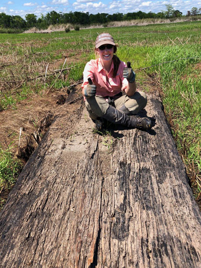
Most of her samples came from the west side of Butler Island, which is bisected by Interstate 95. The island is part of the Altamaha Wildlife Management Area and is maintained by the Georgia Department of Natural Resources, primarily for duck hunting. Robert Horan, DNR senior wildlife manager, leads a cycle of prescribed actions—flooding, draining, burning and mowing—to create an environment rich with vegetation that attracts waterfowl for the 10-week annual hunting period. There are short periods of time when the land is dry, and that’s when Napora got her samples.
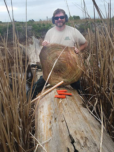
She worked closely with Horan, who earned bachelor’s and master’s degrees in forestry at UGA, and DNR’s Craig Jacobs during her seven or eight visits. Napora typically started at 6 a.m. and worked till sundown. Wearing waders, she tromped along dirt pathways and through flooded ponds to locate the buried trees, marking them with PVC pipe that had bright flagging tape on top. Horan and Jacobs used a 36-inch chainsaw to cut down through the mud and into the tree, and the cookie was pried up using a crowbar or sometimes a wedge and pulley.
It was strenuous work in challenging conditions, but Napora got to experience a part of the island that’s not open to the public. Horan describes it as an extremely rich wildlife environment, with bobcats, deer, waterfowl, snakes, turtles, frogs and the “most healthy and robust population of alligators in the state.” It’s also a productive environment for vegetation, featuring plants like American lotus, lily pads, grasses and sweeps of wildflowers.
“It’s an amazing site,” Napora said. “It’s kind of like a treasure hunt when you’re out there searching for these ancient trees.”
“Kat’s very thorough, and that’s a good thing. With something like this, you don’t want to rush it. To her credit, she really interrogates everything to the nth degree, and to do this work, you have to do that.”
– Victor Thompson, professor and director of UGA’s Laboratory of Archaeology
Photo by Nancy Evelyn
Patterns and plots
Once the cookies arrived on campus, they had to be prepped before Napora could examine their rings. They were sanded with multiple levels of grit and then finished with a metal scraper to open up the cells for viewing under a microscope.
“There are some rings in these trees that are absolutely miniscule,” she said. “If the tree just grew a tiny little bit during the year, you can barely see the ring.”
The basis of dendrochronology is that trees in temperate environments grow one ring every year, Napora said. A ring consists of the light wood that’s laid down in spring and the darker wood that’s laid down in late summer and early fall. They stop growing in winter, and start a new ring in spring. The width of rings in the southeastern United States mostly corresponds with rainfall. A thin ring indicates dry conditions, and a thick ring indicates wet.
Dendrochronology requires matching the ring-width patterns among trees growing in the same area. Since they are exposed to the same environmental conditions, they’ll develop the same annual pattern of thick and thin rings.
In preparation for her project, Napora completed a fellowship at the Laboratory of Tree-Ring Research at the University of Arizona and an internship at a lab in Switzerland. American and European techniques are different; she learned both and combined them for her project.
One American technique she used is skeleton plotting, which involves marking the size of trees’ rings on long, narrow strips of paper that allow for easy visual comparisons between trees. After completing a plot for every tree, Napora matched them against each other.
“That’s how you create a chronology,” she said. “You start with a modern tree so that you know which year the last ring represents, and then you find where that ring-width pattern overlaps with older and older trees to push the pattern farther and farther back into the past.”
In addition to measuring tree rings and creating skeleton plots, Napora conducted radiocarbon dating at UGA’s Center for Applied Isotope Studies, a critical step for this project, which required matching up thousands of years of tree-ring patterns.
“Kat’s very thorough, and that’s a good thing. With something like this, you don’t want to rush it,” Thompson said. “To her credit, she really interrogates everything to the nth degree, and to do this work, you have to do that.”
Napora describes it as a combination of science and art.
“The amount of time that goes into this, all the steps that have to be done: the hand-drawn plots, the measurements, matching multiple measurements from each tree, checking and rechecking the cookies, and using multiple computer programs to conduct statistical analyses,” she said. “The goal of all this is to get to one chain of numbers.”
That one chain of numbers—the chronology—indicates what the environment was like every year, and now Napora can provide that information for a 5,177-year span on the Georgia coast.
“We’re really excited about the information this gives us about the environment in the past,” she said. “I think it will help a lot of people in their research too, to have a more localized year-by-year look at what was happening on the coast here.”
What happened during the timeline of this tree-ring chronology, which covers the period from 3161 B.C.E. to 2016 C.E.?
Use the arrows to navigate through the timeline.


Approximate time that Ötzi the Iceman lived
Photo by Zigres / Shutterstock.com
The oldest tree in the world, a bristlecone pine in California called Methuselah, sprouts

The Great Pyramid of Giza is built
Photo by Andrej Privizer / Shutterstock.com
Indigenous people in the coastal Southeast create the first pottery in North America

The last woolly mammoths on earth die on Wrangel Island off the coast of Russia
Photo by leonello / iStock.com
Tutankhamun becomes Pharaoh of Egypt
Alexander the Great is born

Qin Shi Huang, the first emperor of China, builds the Terracotta Army to guard his mausoleum
Photo by dndavis / iStock.com
Mount Vesuvius erupts, destroying the Roman city of Pompeii
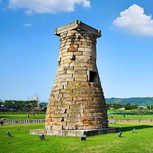
Queen Seondeok of the Silla Kingdom of Korea builds the oldest still-standing astronomical observatory
Photo by Iseo Yang / iStock.com
The Viking Age begins with the attack on Lindisfarne Abbey in England
Founding of the Aztec capital of Tenochtitlan, today Mexico City
Photo by Viktor / iStock.com
Queen Elizabeth I’s navy defeats the Spanish Armada
Founding of the University of Georgia
Photo courtesy of UGA Marketing and Communications
UGA Laboratory of Archaeology is established
UGA grad student Kat Napora begins sampling ancient bald cypress trees at Butler Island
Photo courtesy of Kat Napora
Chronology and a conundrum
Napora is from a different coast—coastal Virginia, near Virginia Beach, where the mid-Atlantic color palette is dominated by pastels like light pinks, light yellows and golden beiges. Georgia is more verdant, with greens and browns, according to Napora.
“It has its own unique look, its own beauty,” she said.
The landscape of the Chesapeake Bay and Atlantic, where she windsurfed and water skied, drove her early interest in marine biology and ecology. She earned her undergraduate degree at the University of Virginia, where she realized that environmental archaeology would allow her to combine her interests, and then earned a master’s degree at the University of Chicago.
“I feel really lucky that I was able to do a specialty like this, looking at the environment in the ancient past and how people interacted with it,” she said.
Napora is committed to making the past relevant to contemporary society, Thompson said.
“She’s not only about, ‘Hey, let’s look at the record and explore the past,’ but also, ‘How does all of this help us in terms of policymaking?’” he said. “‘What can we as paleoclimatologists, archaeologists, ecologists bring to the table that policymakers need to know about?’ She’s embraced that.”
Thompson and Napora are part of the National Science Foundation’s Georgia Coastal Ecosystems Long-Term Ecological Research Project, which brings scientists in many disciplines together to study how the coastal environment is changing. The ancient trees from the Altamaha River provide a deep-time complement to the decades-long LTER studies.
“This is something the taxpayers are supporting,” said Napora, who also received an NSF doctoral dissertation improvement grant. “It’s really important for them to be able to learn about our findings.”
Napora is passionate about sharing her techniques and results, and she developed a series of hands-on activities to teach tree-ring science to undergraduate students. She and Kristine Schenk, manager of the Laboratory of Archaeology, tailored them for different age groups and outreach settings.
And her results from the ancient tree rings are helping to solve a mystery. About 4,000 years ago, there were large settlements of people on Georgia’s barrier islands. Zooarchaeological data reveals that people were staying there year-round and using resources in the estuaries—until the sites were abandoned.
“We think there was some kind of major environmental event,” Napora said. “There are studies from other areas in the world that indicate there was a global environmental downturn that happened around that time period, though it varied based on location. The data from the trees is helping us figure out exactly what happened here on the Georgia coast.”

Napora’s samples may lead to a more precise regional radiocarbon curve—the tool that researchers use to convert radiocarbon years into Gregorian calendar ages. The standard calibration curves cover the northern and southern hemispheres, but “we’re discovering that there are slight regional differences, and understanding those differences gives us a better understanding of timelines in the past,” Napora said. If her samples reveal an offset from the radiocarbon curve in coastal Georgia, adding her data to the curve will allow researchers to make more precise conversions. (Photo by Nancy Evelyn) The chronology shows a period of enhanced environmental fluctuation from 2300-1850 B.C.E, including many very small rings—likely droughts—some of which are preceded by a very large ring. The large ring may point to a series of hurricanes or other storms; the same ring-width pattern is seen for 42% of hurricanes that are known to have impacted the Georgia coast between 1750 and 2012. The environment stabilized for a time, and then a second period of instability began around 1540 B.C.E.—right around the time that people stopped living at some of the large village sites in the region.
“This research is heartening, on the one hand, because we can see that these societies were able to weather a long period of unstable environmental conditions,” Napora said. “However, it’s also cautionary—people ended up changing their longstanding traditions when negative conditions returned. We can take from this a lesson for today: If climate conditions become too bad for too long, we will probably have to change our way of life, too.”
In the future, Napora would like to expand her cookie collection—and her data—up into the Chesapeake Bay and down into Florida.
“There are all these deposits of ancient trees all up and down the east coast eroding out of the sediments that have preserved them for centuries. If we don’t get to them pretty quickly, they’re going to be gone,” she said.
“Paleoenvironmental and archaeological materials can give us so much information about the past and about what happens with climatic changes similar to what we’re seeing today. We have this wealth of knowledge about the past, and I think it’s incumbent on us as scientists to use it to improve the future.”
Related Posts
-
 | November 5, 2019
Engineering researchers explore academic resilience
-
 | July 14, 2020
Ancient oyster shells provide historical insights
-
 | December 1, 2016
Researchers explore and exploit bacterial immune systems